Stone Circles in Strachan Parish
Three stone circles are situated in Strachan Parish. The largest, nestling in a woodland clearing, is the Nine Stanes recumbent circle, conveniently located just 100 metres from a small car park (signposted). Two of the circles, Eslie the Greater and Eslie the Lesser stand half a mile apart in farm fields within sight of one another. The best known, the Nine Stanes Stone Circle, forms a roughly equilateral triangle with them, and once also enjoyed wide views, but now stands within a forestry plantation.

All three stone circles are burial sites, listed national monuments, and should be afforded proper respect by visitors.
The roads leading to them are narrow and do not afford ready parking space, so the best plan is to visit them on foot from the Mulloch Wood car-park. As the round trip from the car-park to the two Esslie Stone Circles is little more than two miles, this makes for a pleasant excursion on a sunny day.
Nine Stanes Recumbent Stone Circle
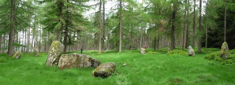
Also known as the Mulloch Stone Circle, Nine Staines is located on the edge of Mulloch Wood in Strachan Parish. [Location map]
The site is a listed national monument [Canmore ID 36748], open to the public and usually accessible at any reasonable time. Signposted from the Forestry Commission car park with room for several vehicles on the north side of A957 (Slug Road).
The stone circle is dated from the Neolithic or Bronze Age, and are thought to have been used to observe the phases of the moon for the purposes of charting the agricultural seasons.
This recumbent stone circle and ring-cairn are situated in a forestry clearing 650m NW of Garrol farmhouse. The stone circle is oval, measuring 17.5m from ENE to WSW by 14.5m transversely, and, in addition to the recumbent and its flankers, comprised eight uprights, one of which is missing and another reduced to a stump.
Known as The Nine Stanes (i.e., nine stone), its name is a misnomer, acquired some time after the removal of one of the orthostats on the NW (8) and the reduction of another to a stump (9); its true complement was eleven stones.
The southernmost of the stones is the recumbent, weighing 16 tons, which was once supported by two upright flanking stones (one now fallen) and the ring measures 17.5m (57 feet) by 14.6m (48 feet).
This stone circle differs from classic examples in having the recumbent and flankers set on the edge of the inner cairn, while the remaining standing stones sit in an oval outer arc, c.18 by 14.6m. It is thought that this circle was built late in the sequence of Recumbent Stone Circles.
Some time after the circle was finished, a low cairn was built inside as a burial monument. This was excavated in 1904 and by now already a potent symbol of the ancestors, evidence of four deposits of cremated bone and one of charcoal mixed with pottery were discovered evidencing the site was once used for the burial of cremated remains.
Eslie the Greater Recumbent Stone Circle (Knock Wood)

Also known as Esslie Major; Eslie South; West Mullo; Eslie Greater Stone Circle, the site is dated to the Neolithic or Bronze Age, and is a listed national monument [Canmore ID; 36714]
This recumbent stone circle encloses a heavily-robbed ring-cairn about 18m in diameter and with a clear court area in the centre about 6m in diameter. on a gentle N-facing slope 730m S of Eslie farmhouse.
In 1873 excavations in the ring-cairn revealed at least three 'dark marks, the length of a not tall human being' together with small pieces of bone, and also a cist 'built of common boulder stones,..from 8 to 10 inches (0.2m to 0.25m) in diameter'; the cist contained 'black marks and pieces of bone'.
Eslie the Lesser Ring Cairn / Stone Circle

Also known as Esslie Minor; Eslie North; West Mullo; or Esslie The Less - the site dates to the Neolithic or Bronze Age. It is a listed national monument [Canmore ID: 36703]
What is probably a ring-cairn surrounded by a stone-circle is situated on a gentle S-facing slope 560m ESE of Eslie farmhouse. The ring-cairn measures about 8.5m in diameter by a maximum of 0.6m in height and there is a large hollow 4.4m in diameter at its centre (possibly caused by excavation in 1873). There are two outer kerbstones (1.2m long by 0.4m high) on the SW and two others on the SSE, but the latter may be displaced. The stone circle measures 12.5m in diameter and has been reduced to six stones from a probable original total of eight or nine (the missing stones lying on the N arc). Two of the stones (only the W is upright) form a pair set close together on the S side of the circle; the W slab measures 1.2m by 0.25m at the base by 1.5m in height, the fallen E slab 1.8m in length by 0.25m in thickness and must have stood at least 0.9m in height. The other stones in the circle range from 1.1m to 1.4m in height.
A ring cairn was either a ritual or funerary site, and in all likelihood, Eslie the Lesser may indeed mark the grave of a pre-historic ancestor.