Picts in Strachan
History of Clan Strachan: Picts in Strachan
The Picts were a loose collection of warlike tribes who lived in the north of Britain. They kept no written records, and much of what we know about the Picts today is from the Romans, and as we know, the Romans were never able to conquer the Picts. Therefore, today we know very little about them.
The lands of Strachan were once located on the northern border of the Pictish kingdom of Circind, which is bounded to the north by the Waters of the Dee and the Pictish Kingdom of Ce (pronounced /cay/).
It is said by Tacidus (a Roman historian) that in 83 A.D. Calgacus ( a chieftain of the Caledonian Confederacy - - or the Picts) fought the Romans at the Battle of Mons Graupius. Many historians believe the battle took place in the Grampian Mountains, and the exact site of the battle remains a mystery.
The book 'Bonnet Lairds' suggests the battle took place very near the Strachan District, but this is a controversial theory that's not widely supported.
The Romans won this battle, but most of the Picts were able to retreat into the Highlands, including Calgacus and escaped the Romans.
There are several sites in Strachan that pre-date the Picts (c. 200 AD to 1199), and in fact date to the Neolithic Period (4300 BC to 2000 BC), Bronze Age (2100 BC to 750 BC), Iron Age (700 BS to 500 AD). .
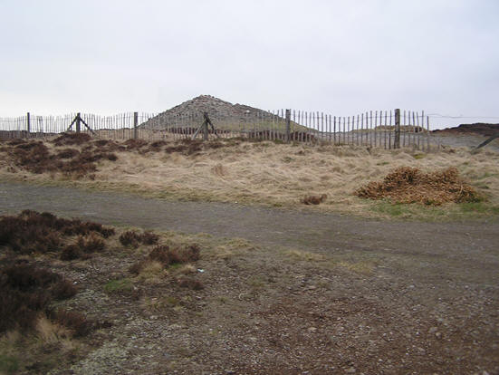
Cairn O' Mount
The Cairn O' Mount lies adjacent and immediately to the west of Old Military Road, and sits atop the Grampian Mountains on the most southern boarder of the Strachan District. Today the Cairn measures 3.5 meters high. The mound has been dated to about 2,000 B.C. (Neolithic Period), and the purpose of the Cairn remains a mystery.
The myth today is that those who pass by and place a stone atop the mound receive luck.
This old drovers road was in the day particularly dangerous. Even today the weather can change quickly and it is one of the first roads in Scotland to close due to snow then a storm comes through. We also know that the road from Fettercairn up to the Cairn O' Mount was, back in the day, fraught with bandits. Those travelling the road were generally well accompanied and well armed. Once you reach the peak of the Cairn O'Mount it comes to reason that travellers would want to have a little luck either before descending into the Howe O' Mearns; or, upon reaching the summit, would want to give thanks for an uneventful assent.
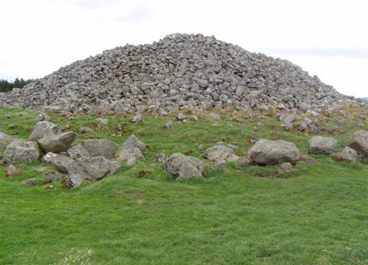
Bucharn Burial Mound
During the late Neolithic and early Bronze Age, a large number of, usually circular, burial mounds were erected in prominent locations to intern important members of the community. The rites of inhumation (in short, stone-lined cist graves), and cremation (in large pottery urns), were practised.
The Bucharn Burial Mound dates to the Bronze Age. It is 6.2 meters in height and 23 meters in diameter, and the burial mound is in excellent condition and undisturbed.
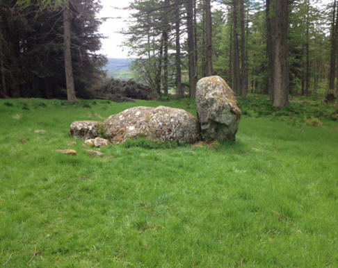
Stone Circles
There are three recumbent stone circles in the eastern part of Strachan (Eslie) , that together form an equilateral triangle, each about a half mile from eachother. These differ from other stone circles in that the center stone is recumbent, or laying on its side. Flanking each side of the recumbent stone are vertical stones.
Albeit two of the stone circles (Eslie the Greater and Eslie the Lesser) in Strachan sit inside farm fields, the most practical to visit is the Nine Stains Stone Circle off the Slug Road, about 2 miles east of the village. It is today located in a forested plantation on the north side of the road. However, back in the day all three stone circles would have been in sight of each other.
The stone circles date back to about 2,000 B.C. The following is an image of Nine Stains, the stone flanking the recumbent on the left has since been fallen.
Castlehill of Strachan
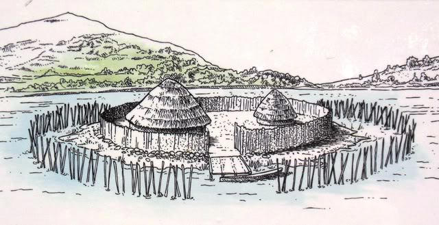
There were two archeological excavations of the site in 1980-81 by Peter Yeoman (source). Evidence from the excavations also suggest the site was occupied during the Mesolithic period sometime between 5,000 to 10,000 B.C. (source). This ancient settlement may have looked like the following image. The river Feugh (pronounced: /few-ich/) ran much closer to the mound than today, and water from the river may have surrounded it. The site also may have included some rudimentary defensive features making it an attractive location during this period.
Mormaer of the Mearns
A Mormaer was the Gaelic name for a regional or provincial ruler, theoretically second only to the King of Scots. Mormaers were equivalent to English earls, and these Mormaers would become by the Early Medieval Period the Earls of Scotland.
The Strachan District lies within the Pictish Kingdom of Circind, which was an area in the East south of the River Dee, and encompassed the modern day counties of Mearns (or Kincardineshire) and Angus. Circind was south of the modern day Earldoms of Mar and Buchan, which lay in the kingdom of Ce (pronounced: /kay/).
Donald I, King of Pictland (r. 858-862) was murdered by Giric, a Gaelic refugee not of royal stock who fled into Pictland, and had befriended Donald I.
This coup d'�tat brought Gaelic culture into Pictavia, and turned the Kingdom of Pictland into a Gaelic kingdom.
Donald I�s son Constantine and teenage cousin Donald fled to their aunt in the North of Ireland, where they were raised and educated in a Gaelic culture themselves.
After a decade in exile the boys returned to Pictland to challenge Giric. Constantine and Donald won back their kingdom, and united the Pictish Kingdom of Dal Reita (or a large part of it) into Pictland.
However, Constantine and Donald left as Pictish boys, and returned as Gaelic princes. From this time, Donald II (r. 989-900) son of Constantine ruled the Gaelic Kingdom of Alba (or Scotia or Scotland), and Pictland was no more. The Prophecy of Berch�n places Donald's death at Dunnottar.
As mentioned previously, the Kingdom of Alba (or Scotland) originally incorporated Pictland and Dal Riata. By 1034, it also included Strathclyde (by marriage) and Lothian.